This post presents a comparative analysis of the extent of the spring flood of the Ural River in Western Kazakhstan in April 2024 and April 2025, compiled using satellite imagery in QGIS.
Context
Flooding remains one of the most pressing issues in our region, causing significant damage to infrastructure and threatening public safety. Traditional monitoring methods, including ground surveys, are labour-intensive, costly and often delayed, particularly in hard-to-reach areas.
Comparing the analysis of satellite data with ground surveys reveals the following advantages:
Timeliness: Rapid data acquisition and processing for a timely response.
Real-time monitoring: Continuous tracking of changes in the water surface.
Wide coverage: Monitoring of vast areas, including hard-to-reach regions.
Data accessibility: The use of open-access Sentinel-2 data from ESA reduces costs and increases the availability of information.
The use of satellite data opens up new opportunities for the rapid and effective monitoring of flood zones, offering advantages not available with traditional approaches.
Research Objectives and Tasks
The aim of the research is to apply advanced remote sensing methods for the accurate and timely mapping of flood-affected areas. The main objective is to accurately identify and map all areas affected by flooding during flood events.
Task: Collection, pre-processing and calibration of satellite imagery to ensure the accuracy of the analysis. Use of the Modified Normalised Difference Water Index for the effective identification of water surfaces. Quantitative assessment of affected areas and calculation of the number of water pixels. Creation of visual maps demonstrating the extent of flooding.
Data and research method
| Parameter | Value |
|---|---|
| Satellite / Sensor | Sentinel-2 (COPERNICUS/S2_SR_HARMONIZED) |
| Spatial resolution | B3 Green — 10 m · B11 SWIR — 20 m |
| Study period | 15 April – 15 May 2024 and 2025 |
| Number of dates | 20 unique dates |
| Imaging date | April 2024 / April 2025 |
| Spectral bands | B3 (Green) — water and vegetation · B11 (SWIR) — water differentiation |
| Index | MNDWI (threshold > 0.2) |
| Software | QGIS / GEE / Google Colab |
Results
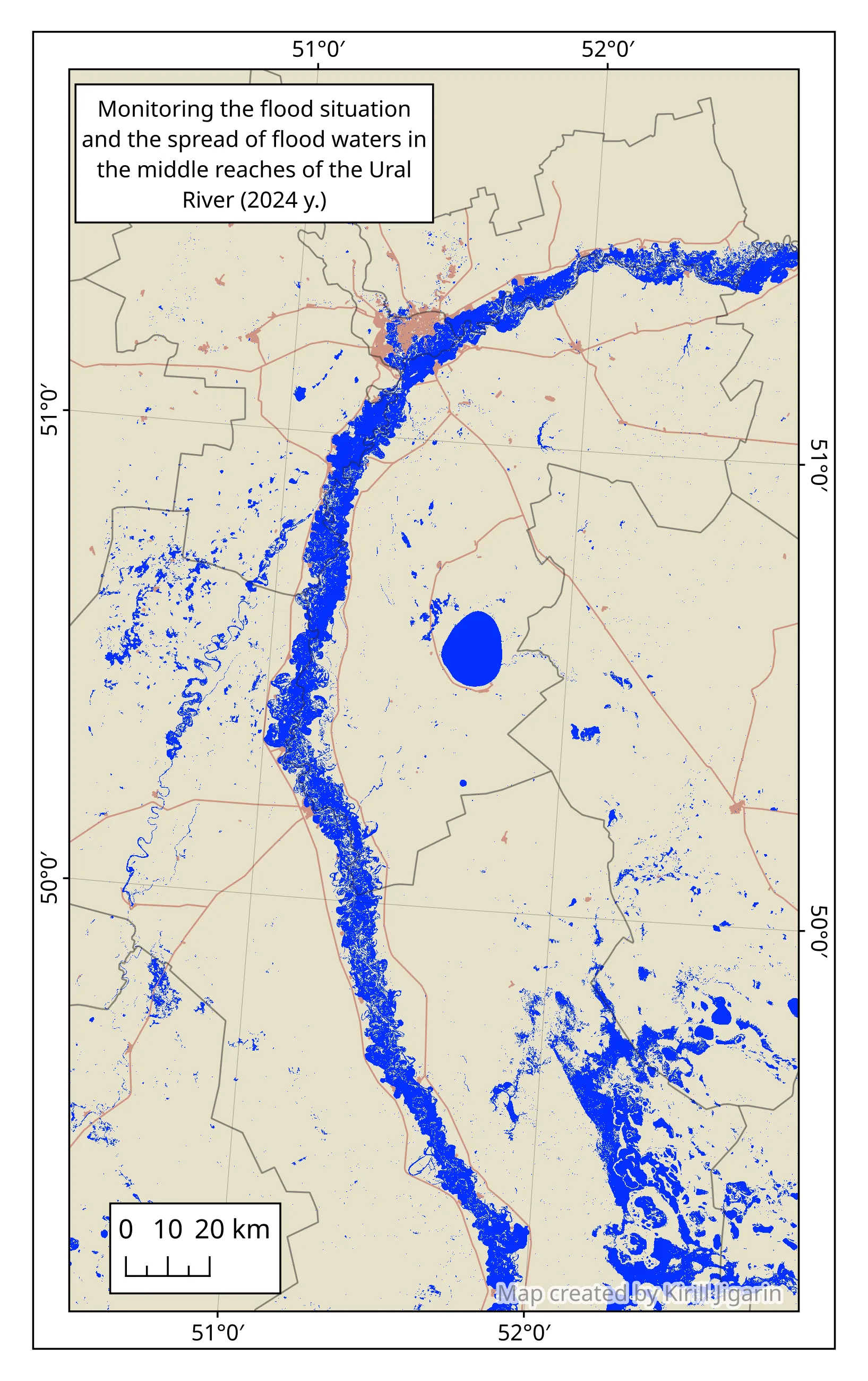
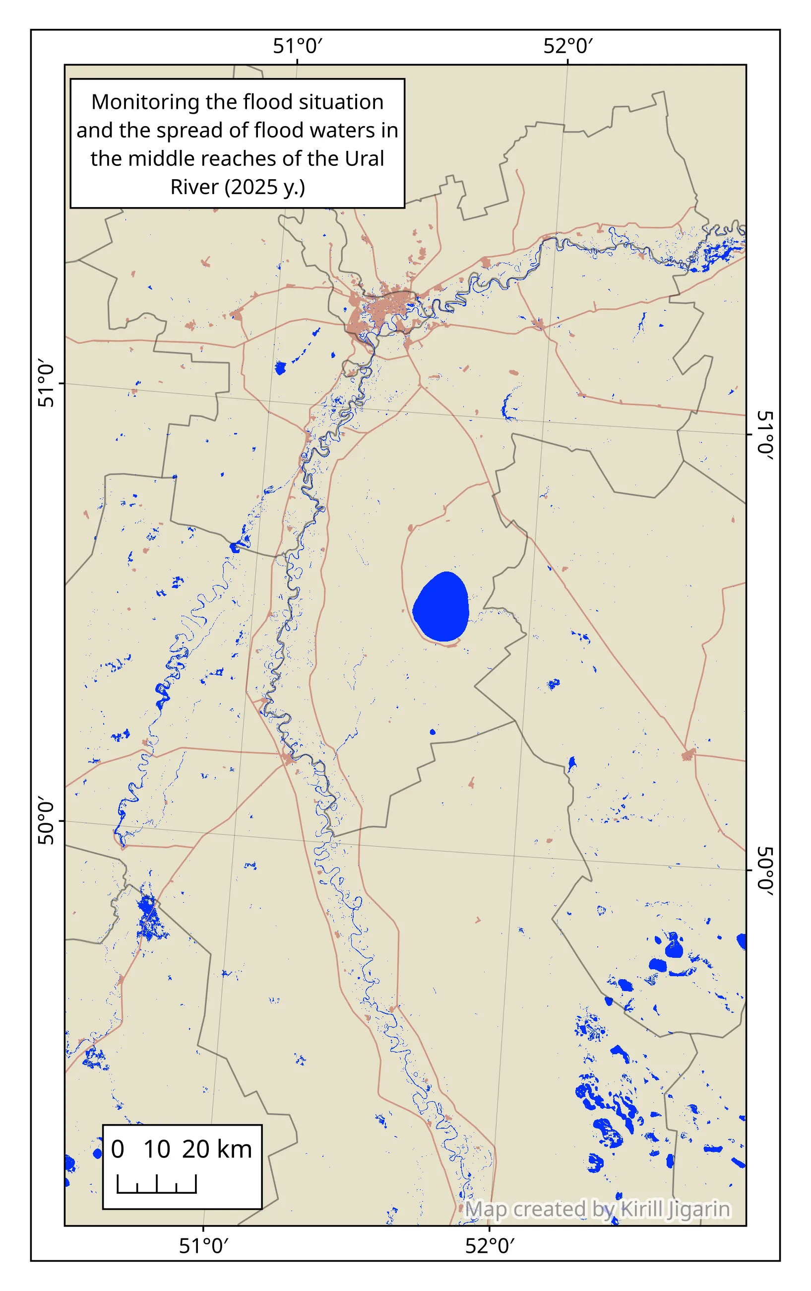
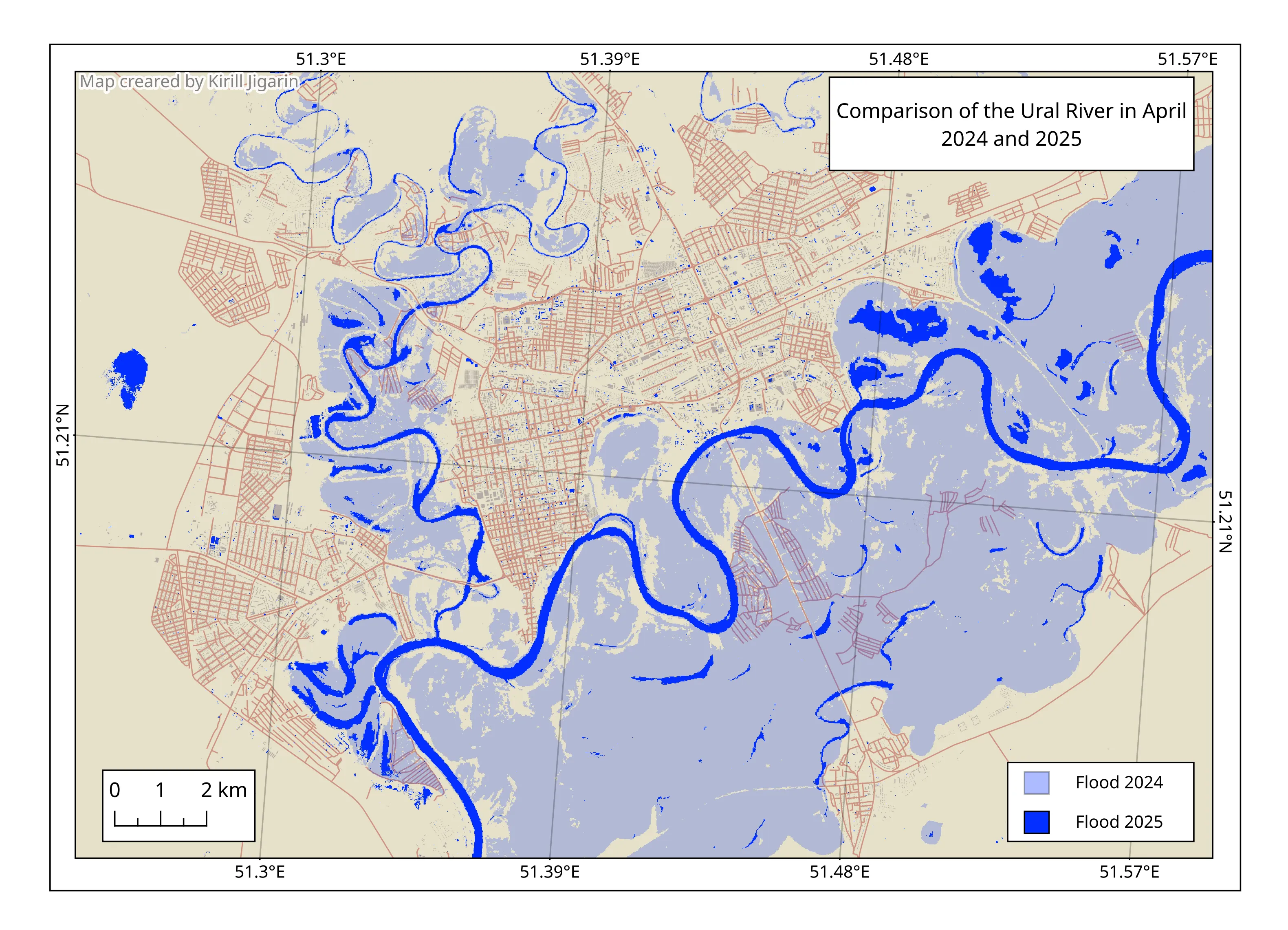
- The area affected by flooding in 2024 was 5,130.99 km², and in 2025 — 1,276.34 km², i.e. 3,854.65 km² more compared to 2025, also according to the official source the total damage in West Kazakhstan Region amounted to 70 billion tenge for the entire West Kazakhstan Region, or 14,739,945.25 US dollars as of 23 April 2026
- During the large-scale floods in the spring of 2024 in the West Kazakhstan Region, the areas most severely affected were those located along the courses of the Ural, Derkul and Chagan rivers and their tributaries.
- Flood maps allow quantitative assessment of damage: the area of affected land, residential areas and infrastructure, and documentation of losses for insurance schemes.
- Evacuation planning — the boundaries of the danger zone are determined within 1–2 days instead of a week of ground surveys; isolated areas are identified (floodplain holiday homes near Uralsk).
- Water resource management — monitoring flood dynamics allows for the optimisation of dam and sluice gate operations, and for flood-prone areas to be taken into account in urban planning policy.
Discussion
The high flood level in April 2025 is due to abnormally high snow accumulation in winter, and rapid snowmelt over a short period, characteristic of the continental climate of Western Kazakhstan. A comparison of the 2024 and 2025 maps shows that floodplains near the city of Uralsk and holiday home estates are subject to flooding every year, indicating the systemic nature of the risk.
Limitations of the method: MNDWI based on Sentinel-2 effectively detects open water, but may underestimate flooding beneath dense vegetation or in cloudy conditions. The resolution of channel B11 (20 m) limits the accuracy of detecting narrow watercourses and small flooded areas.
Conclusion
Satellite monitoring based on Sentinel-2 and the MNDWI index has proven its effectiveness for the rapid mapping of floods in the West Kazakhstan Region. The method allows for the generation of an up-to-date flood map within 1–2 days and ensures accurate detection of open water.
- The area of flooding in April 2024 exceeded the figures for 2025 – the floodplains of the Ural River are subject to systematic risk.
- The most vulnerable areas are holiday home estates and agricultural land in the lower reaches of the Ural River near the city of Uralsk.
- The resulting maps can be used by the Ministry of Emergency Situations to plan evacuations, assess damage and develop urban planning policies in flood-prone areas.